
FLORIDA EAST COAST MARINE WEATHER
The high pressure area responsible for the cool/dry weekend weather will slide east of area waters through the first half of next week, allowing wind to come around to the south with afternoon SE sea breeze enhancement. As the high shifts well east through the second half of the work week, a series of weak frontal boundaries will approach the region. Consequently, afternoon wind surges from the E/SE enhanced by the sea breeze will mess up the surf and may bring wind speeds up to near caution levels over the offshore waters. Surf size will hold into mid-week, then gradually become less consistent and diminish a bit later in the week. Local wind will be lightest each morning, allowing for best surface conditions before noon.
7-DAY SURF FORECAST
WEDNESDAY: Wind light south in the morning, then SE 9-16 mph when the afternoon sea breeze kicks in with waves 1-1.5′ (+/0.5′) in moderate to longer period (9 sec) E/SE swell.
THURSDAY: Wind SW 7-12 mph in the morning, becoming S/SE in the afternoon with waves 1-occ 1.5′ (+/-0.5′) in longer period (9 sec) lingering ESE swell.
FRIDAY(19April): Wind W/NW 6-11 mph in the morning, becoming east in the afternoon with waves dropping down to 1-occ/inc 1.5′ in moderate to longer period (8-9 sec) ENE/E swell.
SATURDAY:
SUNDAY:
MONDAY(22Apr):
TUESDAY:
7-10 DAY WEATHER OUTLOOK (with Hurricane Season Outlook)
Following what may be the last true cold front of spring late last week, a summer-like high pressure ridge (aka Bermuda High) will build across the sub-tropical Atlantic through the forecast period. This set-up will insure modest, consistently rideable easterly swell through most of the week with best local wind conditions in the morning before the afternoon sea breeze kicks in. Surf temps north of the Cape will slowly climb out of the upper 60’sF this week, finally reaching the “magical” 70F-degree mark for good by the end of the week. Toward the end of the month into early May, there is some modeling that suggests a moderately strong low will spin up in the central sub-tropical Atlantic, sending a long period easterly ground swell our way… stay tuned!
CSU’s forecast for an active hurricane season was issued in early April: 2024 Tropical Forecast.
“The ocean is a desert with its life underground, and the perfect disguise up above.” America- A Horse with no Name.
NWS Coastal Waters/Weather Forecast Links
St. Augustine to Flagler Beach
NWS Jacksonville Coastal Forecast
NOAA upgrading nearshore wave prediction.
7-day St. Augustine buoy sea height forecast (primary swell).
Florida Coastal Forecast Map (click on zone)
Marine Page for SE Georgia/NE Florida
_________________________________________________________________________________________
This graph illustrates the 14-day forecast for primary swell height and period for the St. Augustine offshore buoy:
St Augustine buoy 14-day forecast
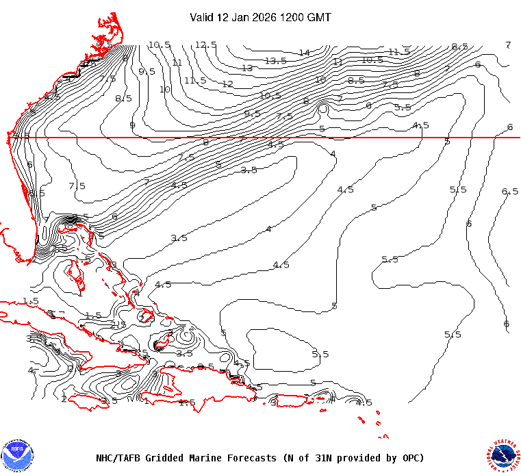
This map illustrates sea height contour (in feet) for the near shore Atlantic Ocean east of Florida:

 ______________________________________________________________________________________________________
Sea surface temps in the GOMEX and western Caribbean Sea.
Watch this GOES loop for lightning signatures that indicate intense convection.
______________________________________________________________________________________________________
The NHC Atlantic Tropical Weather Discussion and the tropical western Atlantic satellite loop are good tools to monitor the Atlantic basin for activity. Good links (updated regularly) to excellent private websites with forecast discussions monitoring tropical and non-tropical weather impacting Florida and the eastern US: Central Florida Hurricane Center and WeatherBELL
Here is a link to the impact hurricane activity has on our coast: Florida beaches face sand shortage
El Nino Southern Oscillation (ENSO) Discussion